


Haut Langdoc etap3

taguette
User
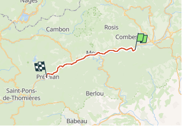

Length
25 km

Max alt
263 m

Uphill gradient
504 m
Km-Effort
31 km

Min alt
164 m

Downhill gradient
420 m
Boucle
No
Creation date :
2024-05-18 05:50:42.733
Updated on :
2024-05-18 12:50:02.591
6h42
Difficulty : Very difficult

FREE GPS app for hiking
 SityTrail
IGN / Geographical institutes
SityTrail Plus
The world is yours!
About
Trail Walking of 25 km to be discovered at Occitania, Hérault, Les Aires. This trail is proposed by taguette.
Positioning
Country:
France
Region :
Occitania
Department/Province :
Hérault
Municipality :
Les Aires
Location:
Unknown
Start:(Dec)
Start:(UTM)
505584 ; 4824929 (31T) N.
Comments